
Search Results
Displaying:
1 - 16 of 16
Controls on Methylmercury Concentrations in Lakes and Streams of Peatland-Rich Catchments Along a 1700 km Permafrost Gradient
Resource
Permafrost thaw may increase the production of neurotoxic methylmercury (MeHg) in northern peatlands, but the downstream delivery of MeHg is uncertain. We quantified total mercury (THg) and MeHg...

COSIA In-Situ Oil Sands Shared Practices for Working in and Around Wetlands
Resource
This report compiles a toolbox of shared practices currently in use by COSIA companies, or which have been used but were found to be unsuccessful.

Large Stocks of Peatland Carbon and Nitrogen are Vulnerable to Permafrost Thaw
Resource
Northern peatlands have accumulated large stocks of organic carbon (C) and nitrogen (N), but their spatial distribution and vulnerability to climate warming remain uncertain. Here, we used machine...
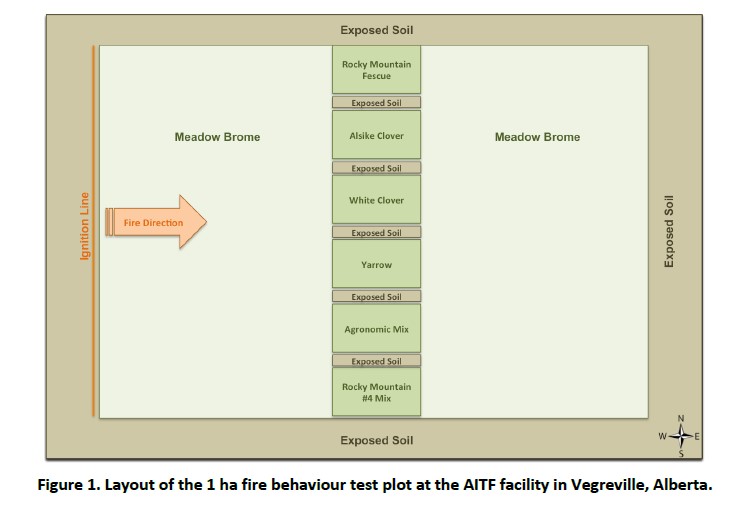
Less Flammable Vegetation for Linear Industry Rights-‐of-‐way
Resource
FPInnovations launched a multi-year study to determine whether a less-flammable, herbaceous species could replace the flammable grasses that typically colonize linear ROWs
Microtopography Matters: Belowground CH4 Cycling Regulated by Differing Microbial Processes in Peatland Hummocks and Lawns
Resource
This resource is available on an external database and may require a paid subscription to access it. It is included on the CCLM to support our goal of capturing and sharing the breadth of all...

Resource Roads and Wetlands: A Guide for Planning, Construction, and Maintenance
Resource
This guide contains best management practices that help plan, construct and maintain resource roads in forested environments in order to maintain the movement of water in wetlands.

Resource Roads and Wetlands: Practical Applications to Maintain Hydrologic Connectivity
Resource
This presentation highlights planning and operations applications of water management techniques for resource roads crossing wetlands.

Shrub Changes with Proximity to Anthropogenic Disturbance in Boreal Wetlands Determined Using Bi-temporal Airborne LiDAR in the Oil Sands Region, Alberta Canada
Resource
Bi-temporal LiDAR data used to identify correspondence between density of anthropogenic disturbances, wetland shape complexity and changes in vegetation height within >1800 wetlands near Fort McKay
The Boreal-Arctic Wetland and Lake Dataset
Resource
Here we present the Boreal–Arctic Wetland and Lake Dataset (BAWLD), a land cover dataset based on an expert assessment, extrapolated using random forest modelling from available spatial datasets of...
The Effects of Black Spruce Fuel Management on Surface Fuel Condition and Peat Burn Severity in an Experimental Fire
Resource
This resource is available on an external database and may require a paid subscription to access it. It is included on the CCLM to support our goal of capturing and sharing the breadth of all...
Video - Resource Roads and Wetlands: Road Construction Considerations
Resource
Canada’s forested landscapes feature numerous wetlands, such as fens, bogs and swamps, which present environmental and operational challenges during the planning, construction and maintenance of...
Webinar - Developing Best Management Practices for Resource Roads and Wetlands
Resource
This webinar provides an overview of a resource roads and wetlands field guide completed by Ducks Unlimited Canada and FPInnovations.

Webinar - Measuring Carbon in Wetlands: A Rapid Assessment Protocol
Resource
This webinar provides an overview of a project funded by the Sustainable Forestry Initiative that involves collaboration among the Saskatchewan Research Council, Ducks Unlimited Canada, Louisiana...
