
Search Results
Displaying:
21 - 40 of 62
Labrador Boreal Caribou Population Monitoring
Project
Contact
Organization:
Project DescriptionThe Labrador Boreal Caribou Population Monitoring Program is being implemented according to an action item outlined in the Woodland Caribou (Boreal population) in Newfoundland and...

Manipulations of Black Bear and Coyote Affect Caribou Calf Survival
Resource
This resource is available on an external database and may require a paid subscription to access it. It is included on the CCLM to support our goal of capturing and sharing the breadth of all...

Monitoring Procedures for Wellsite, In-Situ Oil Sands and Coal Mine Reclamation in Alberta – December 2014 Update
Resource
Scope of the project is to develop a geomatics-based monitoring system to support the Government of Alberta’s efforts for monitoring reclamation success. Software will support decision making process

Natural Recovery on Low Impact Seismic Lines in Northeast British Columbia
Project
Contact
Project Description WSP Golder (formerly Golder Associates Ltd) and Explor were supported by the Research and Effectiveness Monitoring Board (REMB) of the BCIP initiative, with funding provided by the...
Natural Recovery on Low Impact Seismic Lines in Northeast British Columbia
Resource
WSP Golder (formerly Golder Associates Ltd) and Explor were supported by the Research and Effectiveness Monitoring Board (REMB) of the BCIP initiative, with funding provided by the BC Oil and Gas...

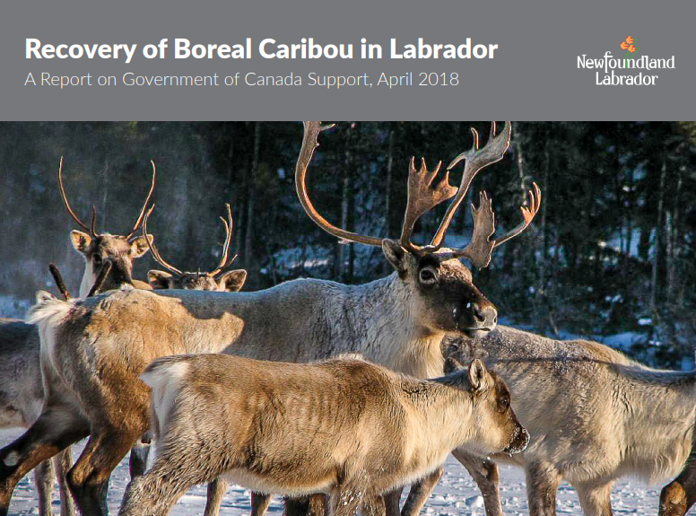
Recovery of Boreal Caribou in Labrador
Resource
Newfoundland and Labrador is home to several herds of caribou; the island population, the migratory George River caribou (northern Labrador), and perhaps the most sensitive, the boreal herds of...
Recovery Strategy for Three Woodland Caribou Herds (Rangifer tarandus caribou; Boreal Population) in Labrador
Resource
The Recovery Strategy for Woodland Caribou (Boreal population) in Labrador is a document prepared by the Labrador Woodland Caribou Recovery Team to identify recovery strategies deemed necessary, based...
Recreational Trail Impacts on the Plant Communities of Castle and Castle Wildland Provincial Parks in Southern Alberta
Resource
I measured the effect of recreational trails on plant species richness, community composition, and the presence of exotic and rare species in the Castle Provincial Parks of Alberta, Canada, by...

Satellite-detected Decreases in Caribou Lichen Cover, Cladonia (Cladina) spp., Over Eastern Canada During the Last Three Decades
Resource
This resource is available on an external database and may require a paid subscription to access it. It is included on the CCLM to support our goal of capturing and sharing the breadth of all...
Seismic Line Impacts on Proximal Boreal Forest and Wetland Environments in Alberta
Resource
This resource is available on an external database and may require a paid subscription to access it. It is included on the CCLM to support our goal of capturing and sharing the breadth of all...

Shortening Fire Return Interval Predisposes West-Central Canadian Boreal Peatlands to More Rapid Vegetation Growth and Transition to Forest Cover
Resource
Climate change in northern latitudes is increasing the vulnerability of peatlands and the riparian transition zones between peatlands and upland forests (referred to as ecotones) to greater frequency...

Shrub Changes with Proximity to Anthropogenic Disturbance in Boreal Wetlands Determined Using Bi-temporal Airborne LiDAR in the Oil Sands Region, Alberta Canada
Resource
Bi-temporal LiDAR data used to identify correspondence between density of anthropogenic disturbances, wetland shape complexity and changes in vegetation height within >1800 wetlands near Fort McKay

The Biophysical Climate Mitigation Potential of Boreal Peatlands During the Growing Season
Resource
Peatlands and forests cover large areas of the boreal biome and are critical for global climate regulation. They also regulate regional climate through heat and water vapour exchange with the...
Theses - University of Lethbridge
Project
Organization:
Electronic theses from University of Lethbridge students.
Tree Species Mapping Around Reclaimed Oil and Gas Wells Sites Using Hyperspectral and Light Detection and Ranging (LiDAR) Remote Sensing
Resource
Oil and gas activities in Alberta require disturbing forested lands, among other ecosystems, in order to extract resources. Due to the number of oil and gas sites requiring reclamation, monitoring can...

Video - A multi-level classification for Boreal wetlands
Resource
This presentation discusses the need for a multi-level classification for boreal wetlands and accurate change detection.
