Wetlands Knowledge Search Results
Resource
In this study, phospholipid fatty acids (PLFA) and carbon isotopes were used to characterize the response of in situ microbial communities to a pilot-scale wetland reclamation project in the Alberta...
Resource
Determine what spring spawners utilized these sections of the Athabasca and Clearwater rivers; locate and describe their spawning grounds; and describe the timing of spawning, hatching, and emergence
Resource
Authors
John Gibson
P. Eby
Jean Birks
Colin Twitchell
C. Gray
J. Kariyeva
Water sampling for stable isotopes ( 18O and 2H) was carried out during 2009–2019 across Alberta, Canada, as part of a survey targeting 1022 open water wetlands. The study presents the first site...
Resource
Authors
John Gibson
Jean Birks
Michael Moncur
Yi Yi
K. Tattrie
S. Jasechko
K. Richardson
P. Eby
Pilot study to assess potential for labelling process-affected water from oil sands operations using a suite of isotopic and geochemical tracers
Resource
Resource Date:
December
2022
The Kitaskino Nuwenëné Wildland has now been expanded, adding around 152,000 hectares to the largest contiguous area of protected land in the world. The expanded area was previously managed as Green...
Resource
Authors
Jon Hornung
Carla Wytrykush
G. Haekel
Theo Charette
Marsha Trites
Subject matter experts were asked to participate in a multi-year process to review, interpret and synthesise results on marsh (open water wetland) reclamation and research in the oil sands region
Resource
Planned increases in oil sands developments with increased outputs of oxides of sulphur and nitrogen, led to a definitive study to assess the susceptibility of nearby lakes to acidification
Resource
Authors
Zhan Li
Joanne White
Michael Wulder
Txomin Hermosilla
Andrew Davidson
Alexis Comber
Large-area land cover maps are produced to satisfy different information needs. Land cover maps having partial or complete spatial and/or temporal overlap, different legends, and varying accuracies...
Resource
Authors
NAIT Centre for Boreal Research
This flowchart outlines each step of the treatment process for forest land (upland) landscape as incorporated in the corresponding Decision Support Systems (DSS). View more tools by NAIT Centre for...
Resource
Authors
NAIT Centre for Boreal Research
This flowchart outlines each step of the treatment process for forest land (upland) soil as incorporated in the corresponding Decision Support Systems (DSS). View more tools by NAIT Centre for Boreal...
Resource
Authors
NAIT Centre for Boreal Research
This flowchart outlines each step of the treatment process for forest land (upland) vegetation as incorporated in the corresponding Decision Support Systems (DSS). View more tools by NAIT Centre for...
Resource
Authors
B. Critescu
Gordon Stenhouse
Marc Symbaluk
M.S. Boyce
Following closure, access management on designated trails will reduce risk of conflicts. Imposing access restrictions, preserving undisturbed habitat patches and restoring original vegetation
Resource
Authors
Camile Sothe
Alemu Gonsamo
Joyce Arabian
James Snider
Resource Date:
August
2021
Canada has extensive forests and peatlands that play key roles in global carbon cycle. Canadian soils and peatlands are assumed to store approximately 20% of the world’s soil carbon stock. However...
Resource
Authors
Evan DeLancey
Jahan Kariyeva
Jason Bried
Jennifer Hird
The resulting peatland occurrence model shows an accuracy of 87% compared to our validation data set. Differentiating peatlands from mineral wetlands achieved an accuracy of 69%.
Resource
Authors
Jasmeen Kaur
Amanda Schoonmaker
Jean-Marie Sobze
Abstract: Alnus viridis (Chaix) DC. subsp. crispa (Aiton) Turrill (Betulaceae), commonly known as green alder or mountain alder, is a boreal shrub used to revegetate disturbed lands because of its...
Resource
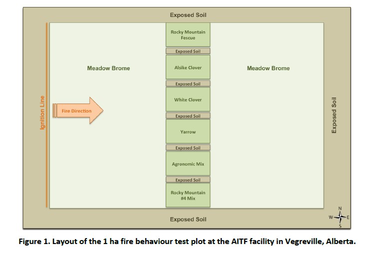
FPInnovations launched a multi-year study to determine whether a less-flammable, herbaceous species could replace the flammable grasses that typically colonize linear ROWs
Resource
Authors
Lorna Harris
Tim Moore
Nigel Roulet
Andrew Pinsonneault
Resource Date:
March
2018
The fruticose lichens Cladina stellaris and Cladina rangiferina, form thick mats that can cover large areas of northern peatlands (above c. 50° latitude), including the extensive peatlands of the...
Resource
Authors
Sharad Karmacharya
Marc Symbaluk
David Brand
S. Schwartz
The Luscar and Gregg River Mines Land Management Plan Working Group was formed to develop a land management plan. The process engaged stakeholders representing a variety of community interests
Resource
Authors
Stephen Mayor
Stan Boutin
Fangliang He
James Cahill
Rank species occupancy curves revealed high species dominance regardless of disturbance: within any disturbance class a few species occupied nearly every site and most species were found in a low...
Resource
This presentation discusses linear feature disturbances or boreal peatlands and reclamation trials of various sites. Presented at the NAIT 7th Seminar on Linear Disturbance Impacts on Boreal Wetland...