Land Management Search Results
Resource
Authors
Anne Naeth
Donna White
David Chanasyk
Terry Macyk
Chris Powter
Don Thacker
To provide coordinated direction for reclamation research in Alberta, the need to review the current understanding and the role of soil physical properties in soil disturbance related activities was...
Resource
Authors
Alberta Soils Advisory Committee
Land disturbances due to resource extraction and transport are intended to be only temporary disruptions to the normal use of land for food and fiber production or for recreation. Although no two...
Resource
Authors
Pedocan Land Evaluation Ltd.
Part 1 of this manual is a background and explanatory section that describes the terminology used in soil surveys and presents the assumptions and conventions upon which the interpretations are based
Resource
Authors
Pedocan Land Evaluation Ltd.
Part 2 presents typical data and interpretations for each soil series in Alberta. The interpretations were made by applying the guidelines in Part 1, and checking the results against experience
Resource
Authors
Clayton Apps
Bruce Mclellan
Trevor Kinley
Robert Serrouya
Dale Seip
Heiko Wittmer
Resource Date:
August
2013
This resource is available on an external database and may require a paid subscription to access it. It is included on the CCLM to support our goal of capturing and sharing the breadth of all...
Resource
Authors
Fabien St-Pierre
Pierre Drapeau
Martin-Hughes St-Laurent
Resource Date:
February
2022
By showing which forest roads are more used by caribou predators (wolves and bears) and its apparent competitor (moose), our study highlights the importance of considering both road-scale characteristics and the landscape context in which roads are built to prioritize the most detrimental roads to caribou conservation and guide efficient restoration efforts of its habitat.
Resource
One-hundred-year-old mixed white spruce–aspen stands were partially cut in 1953, 1954, and 1955 and scarified leaving treatments that retained 14–100% of total stand basal area. Composition of the...
Resource
Authors
Alberta Biodiversity Monitoring Institute
This online report describes the status of human footprint, species, and habitat in Norbord Inc.'s two main operating areas located in northwestern Alberta. This information establishes baseline...
Project
Project Description: Biigtigong Nishnaabeg has developed a (draft) caribou Stewardship Plan for its traditional territory, which includes a portion of the Lake Superior Caribou Range and the...
Resource
Authors
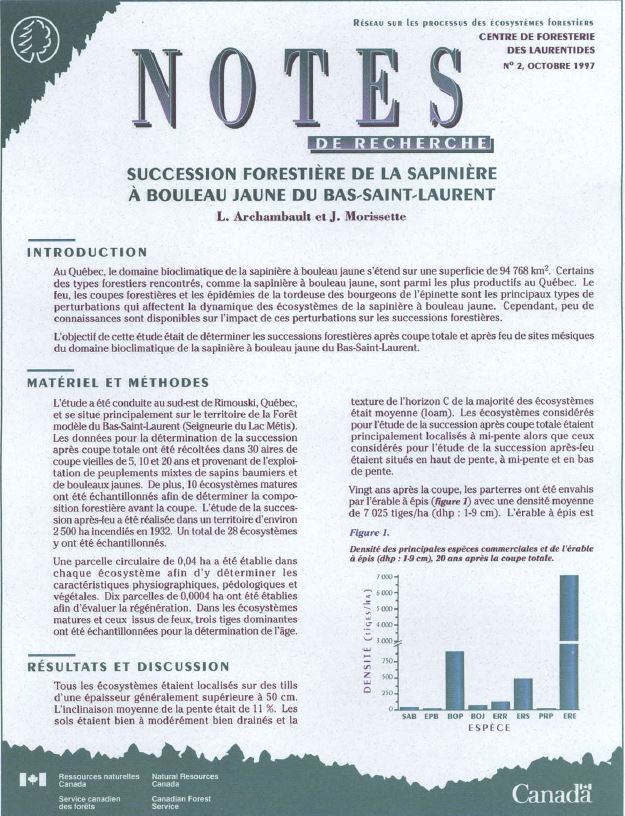
L. Archambault
J. Morissette
In Quebec, the bioclimatic zone of balsam fir-yellow birch covers an area of 94,768 km 2. Some of the forest cover types in the area, such as balsam fir-yellow birch, are among the most productive in...
Resource
Authors
Michael Ryan
David Fraser
Valin Marshall
Fangliang He
Six chronosequences were established on southern Vancouver Island, British Columbia, to address the concerns regarding the potential loss of species diversity and increased risk to rare or old-growth...
Resource
Authors
Craig DeMars
Kendal Benesh
The boreal ecotype of woodland caribou ( Rangifer tarandus caribou) is provincially Red-listed in British Columbia and federally listed as Threatened. Population declines of boreal caribou have been...
Project
The Boreal Caribou Ecological Model Developed by the Habitat Restoration Working Group (HRWG) of the National Boreal Caribou Knowledge Consortium (NBCKC). Habitat restoration is expected to play a key...
Resource
The Boreal Caribou Ecological Model is a conceptual model which illustrates the key ecosystem factors, mechanisms, pathways and interactions mediating the well known national disturbance-recruitment...
Resource
Authors
Alexander Prichard
Joseph Welch
Brian Lawhead
Resource Date:
March
2022
Academic journal article on the effects of traffic and infrastructure on the behaviour of calving caribou in Alaska.
Resource
Authors
Victoria Donovan
Glen Brown
Frank Mallory
Resource Date:
February
2017
Loss or alteration of forest ecosystems due to anthropogenic activities has prompted the need for mitigation measures aimed at protecting habitat for forest-dependent wildlife. Understanding how...
Resource
Authors
Erin Bayne
Cameron Nordell
Jesse Watson
Melynda Johnson
Adam Moltzahn
Janet Ng
The Ferruginous Hawk (FEHA) has been listed as an Endangered Species under the Alberta Wildlife Act by the provincial government since 2006 (Alberta FEHA Recovery Team 2009); and were re-listed as a...
Resource
Authors
Angeline Van Dongen
Caren Jones
Amanda Schoonmaker
Jill Harvey
Dani Degenhardt
Resource Date:
November
2022
Alberta’s forests are becoming increasingly disturbed and fragmented by the cumulative effects of anthropogenic distur�bances exacerbated by the enduring footprint of seismic lines on the landscape...
Resource
Authors
Guillermo Castilla
Ronald Hall
Rob Skakun
Michelle Filiatrault
André Beaudoin
Michael Gartrell
Lisa Smith
Kathleen Groenewegen
Chris Hopkinson
Jurjen van der Sluijs
Resource Date:
February
2022
Wall-to-wall 30 m raster maps of broad forest type, stand height, crown closure, stand volume, total volume, aboveground biomass, and stand age were created for a ~400,000 km2 area, validated with independent data, and generalized into a polygon GIS layer resembling a traditional FI map. The MVI project showed that a reasonably accurate FI map for large, remote, predominantly non-inventoried boreal regions can be obtained at a low cost by combining limited field data with remote sensing data from multiple sources.
Resource
Authors
Majid Iravani
Monica Kohler
Shannon White
The results showed a pronounced variation in the historic supply of soil organic carbon and aboveground biomass in the watershed. Land management resulted in a diverse range of gains or losses.