Land Management Search Results
Resource
Authors
Clayton Apps
Bruce Mclellan
Trevor Kinley
Robert Serrouya
Dale Seip
Heiko Wittmer
Resource Date:
August
2013
This resource is available on an external database and may require a paid subscription to access it. It is included on the CCLM to support our goal of capturing and sharing the breadth of all...
Resource
One-hundred-year-old mixed white spruce–aspen stands were partially cut in 1953, 1954, and 1955 and scarified leaving treatments that retained 14–100% of total stand basal area. Composition of the...
Resource
Authors
Alberta Biodiversity Monitoring Institute
This online report describes the status of human footprint, species, and habitat in Norbord Inc.'s two main operating areas located in northwestern Alberta. This information establishes baseline...
Project
Project Description: Biigtigong Nishnaabeg has developed a (draft) caribou Stewardship Plan for its traditional territory, which includes a portion of the Lake Superior Caribou Range and the...
Resource
Authors
L. Archambault
J. Morissette
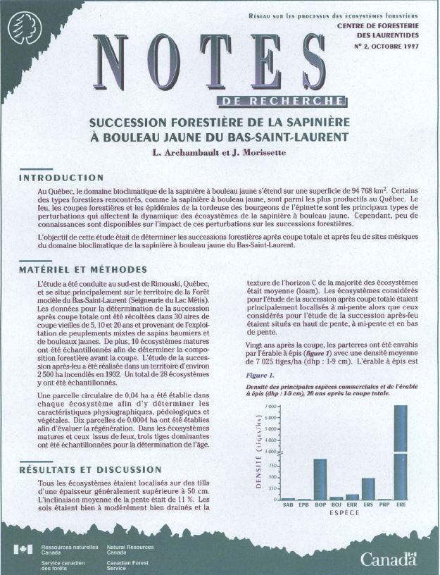
In Quebec, the bioclimatic zone of balsam fir-yellow birch covers an area of 94,768 km 2. Some of the forest cover types in the area, such as balsam fir-yellow birch, are among the most productive in...
Resource
Authors
Michael Ryan
David Fraser
Valin Marshall
Fangliang He
Six chronosequences were established on southern Vancouver Island, British Columbia, to address the concerns regarding the potential loss of species diversity and increased risk to rare or old-growth...
Project
The Boreal Caribou Ecological Model Developed by the Habitat Restoration Working Group (HRWG) of the National Boreal Caribou Knowledge Consortium (NBCKC). Habitat restoration is expected to play a key...
Resource
The Boreal Caribou Ecological Model is a conceptual model which illustrates the key ecosystem factors, mechanisms, pathways and interactions mediating the well known national disturbance-recruitment...
Resource
Authors
Victoria Donovan
Glen Brown
Frank Mallory
Resource Date:
February
2017
Loss or alteration of forest ecosystems due to anthropogenic activities has prompted the need for mitigation measures aimed at protecting habitat for forest-dependent wildlife. Understanding how...
Resource
Authors
Angeline Van Dongen
Caren Jones
Amanda Schoonmaker
Jill Harvey
Dani Degenhardt
Resource Date:
November
2022
Alberta’s forests are becoming increasingly disturbed and fragmented by the cumulative effects of anthropogenic distur�bances exacerbated by the enduring footprint of seismic lines on the landscape...
Resource
Authors
Guillermo Castilla
Ronald Hall
Rob Skakun
Michelle Filiatrault
André Beaudoin
Michael Gartrell
Lisa Smith
Kathleen Groenewegen
Chris Hopkinson
Jurjen van der Sluijs
Resource Date:
February
2022
Wall-to-wall 30 m raster maps of broad forest type, stand height, crown closure, stand volume, total volume, aboveground biomass, and stand age were created for a ~400,000 km2 area, validated with independent data, and generalized into a polygon GIS layer resembling a traditional FI map. The MVI project showed that a reasonably accurate FI map for large, remote, predominantly non-inventoried boreal regions can be obtained at a low cost by combining limited field data with remote sensing data from multiple sources.
Resource
As Canadians, our forests permeate our lives, and Canada’s forest sector is an essential economic engine and major employer of Canadians, including in Indigenous and rural communities. The theme of...
Resource
Authors
Natural Resources Canada (NRCan)
In this 31st edition of The State of Canada’s Forests, the theme is Canada’s forests provide solutions to a changing world. The report highlights how the integrated social, environmental and economic...
Resource
Authors
Y. Huberman
J. Beckers
R. Brett
G. Castilla
R. Errington
E.C. Fraser-Reid
D. Goodsman
E.H. Hogg
J. Metsaranta
E. Neilson
J. Olesinski
M.-A. Parisien
D. Price
T. Ramsfield
C. Shaw
D. Thompson
M.F. Voicu
E. Whitman
J. Edwards
The climate in Canada’s north has changed over the past 70 years. Indeed, mean annual temperature in the Northwest Territories has increased by 2°C to 4°C since record keeping began in 1950. Annual...
Resource
Authors
David Beauchesne
Jochen Jaeger
Martin-Hugues St-Laurent
Resource Date:
March
2014
This resource is available on an external database and may require a paid subscription to access it. It is included on the CCLM to support our goal of capturing and sharing the breadth of all...
Resource
Authors
Karine Pigeon
Meghan Anderson
Doug MacNearney
Jerome Cranston
Gordon Stenhouse
Laura Finnegan
This resource is available on an external database and may require a paid subscription to access it. It is included on the CCLM to support our goal of capturing and sharing the breadth of all...
Project
Project Description: Dismantling 30 km of forest roads. They test different techniques including soil preparation and planting trees. It was to test the operational feasibility and identify cost...
Project
Project Description: Dismantling 76.5 km of forest roads. We test different techniques including soil preparation, water course crossing removing and planting four species of trees. It was to test the...
Resource
Authors
Robert Serrouya
Melanie Dickie
Clayton Lamb
Harry van Oort
Allicia Kelly
Craig DeMars
Philip McLoughlin
Nicholas Larter
Dave Hervieux
Adam Ford
Stan Boutin
Resource Date:
January
2021
Conservation actions directed at the proximate cause of caribou decline have been more successful in the near term than those directed further along the trophic chain.
Resource
Authors
Katherine Dearborn
Jennifer Baltzer
Resource Date:
March
2021
This resource is available on an external database and may require a paid subscription to access it. It is included on the CCLM to support our goal of capturing and sharing the breadth of all...