Land Management Search Results
Resource
Mapping of oil reserves involves the use of seismic lines (linear disturbances) to determine size of reserves. These linear disturbances fragment forests and in many cases fail to regenerate trees...
Resource
Modelling results for the regional watersheds were encouraging and demonstrate that SWATBF has the potential to be utilized as a practical tool for conducting hydrologic assessments in the oil sands
Resource
Authors
Chantel Markle
Paul Moore
Mike Waddington
Identifying ecosystems resilient to climate and land-use changes is recognized as essential for conservation strategies. However, wetland ecosystems may respond differently to stressors depending on...
Resource
Authors
Alberta Biodiversity Monitoring Institute
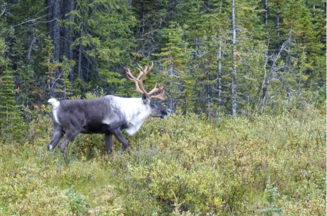
Boreal caribou populations are declining across Alberta and much of their Canadian range. Key factors causing this decline include a warming climate along with habitat change from industrial...
Resource
Authors
Alberta Biodiversity Monitoring Institute
Seismic lines and other linear features created by humans are thought to negatively impact woodland caribou. It is estimated that there are c. 100,000 km of conventional seismic lines in caribou...
Resource
Authors
Alberta Biodiversity Monitoring Institute
Resource Date:
January
2020
Linear features, including seismic lines, pipelines, transmission lines, roads, railways, and trails are pervasive in Alberta’s boreal forest and have been implicated as a primary factor leading to...
Resource
Authors
Nobuya Suzuki
Katherine Parker
Resource Date:
December
2019
Highlights • Maintain connectivity to preserve high-value habitats of caribou and grizzly bears. • Avoiding predation risk does not always maintain intact habitat for caribou. • Conserving most...
Resource
Authors
Richard Schneider
Erin Bayne
Our climate envelope projections for the 2080s indicate that virtually all reserves will, in time, be comprised of different ecosystem types than today.
Resource
Authors
Alberta Environmental Protection, Technical Services and Monitoring Division
Study was undertaken in response to concerns raised by the City of Fort McMurray over the validity of the elevation established in previous studies as representing the 1 in 100 year design flood level
Resource
ALCES models future changes based on known environment and landscape cover, an understanding of historic changes, and projected indicators of change to the environment, human footprint and landscape.
Resource
Sahtú Environmental Research and Monitoring (ERM) Forum meeting presentation of the Sahtu Regional Environmental Decision Support Tool Set.
Resource
Authors
Laura Chasmer
Edberto Moura Lima
Craig Mahoney
Chris Hopkinson
Joshua Montgomery
Danielle Cobbaert
Resource Date:
August
2021
Bi-temporal LiDAR data used to identify correspondence between density of anthropogenic disturbances, wetland shape complexity and changes in vegetation height within >1800 wetlands near Fort McKay
Resource
Authors
P. Wallis
Eric Peake
Melvin Strosher
B. Baker
S. Telang
Provide a problem analysis of the goal to determine the assimilative capacity of the Athabasca River with special regard to organics
Resource
Authors
Dale Vitt
Melissa House
Lilyan Glaeser
Minerogenous peatlands that accumulate deep deposits of organic matter (fens) were an important part of the pre-disturbance landscape across Alberta’s oil sands mining area. Bryophytes occupy 80–100%...
Resource
Authors
Paul Pickell
David Andison
Nicholas Coops
Sarah Gergel
Peter Marshall
Resource development can have significant consequences for the distribution of vegetation cover and for species persistence. Modelling changes to anthropogenic disturbance regimes over time can...
Resource
Authors
Cesar Estevo
Diana Stralberg
Scott Nielsen
Erin Bayne
Climate change refugia are areas that are relatively buffered from contemporary climate change and may be important safe havens for wildlife and plants under anthropogenic climate change. Topographic...
Resource
Authors
Richard Schneider
Grant Hauer
Vic Adamowicz
Stan Boutin
This resource is available on an external database and may require a paid subscription to access it. It is included on the CCLM to support our goal of capturing and sharing the breadth of all...
Resource
Authors
David Latham
Cecilia Latham
Mark Boyce
Stan Boutin
In this study, we examined seasonal coyote and black bear use of industrial linear features and rivers and streams (i.e. natural linear features). We used two methods to assess movement behavior...
Resource
Understanding how populations are structured and how they use natural and anthropogenic spaces is essential for effective wildlife management. A total of 510 barren-ground ( Rangifer tarandus...
Resource
Seismic lines are slow to recover naturally, and many seismic lines need to be restored to contribute towards caribou recovery. Caribou predators use seismic lines to travel throughout caribou ranges...