Land Management Search Results
Resource
Authors
Karin M. Kettenring
Annie L. Henry
Rae Robinson
Kate Sinnott
Mark Brunson
Adrienne Ernst
Emily Tarsa
As the U.N. Decade on Restoration progresses, the demand for genetically and species-diverse native plant materials for restoration is expected to increase. However, little is known about the...
Resource
Authors
Amanda Schoonmaker
Eckehart Marenholtz
Jean-Marie Sobze
Ann Smreciu
Alberta’s forest land reclamation criteria require the establishment of multi-strata vegetation that includes a shrub layer. Establishment of a shrub layer requires the acquisition of seed from a...
Resource
Authors
Kimberly Dawe
Erin Bayne
Stan Boutin
This resource is available on an external database and may require a paid subscription to access it. It is included on the CCLM to support our goal of capturing and sharing the breadth of all...
Resource
Authors
Jasmeen Kaur
Amanda Schoonmaker
Jean-Marie Sobze
Abstract: Alnus viridis (Chaix) DC. subsp. crispa (Aiton) Turrill (Betulaceae), commonly known as green alder or mountain alder, is a boreal shrub used to revegetate disturbed lands because of its...
Resource
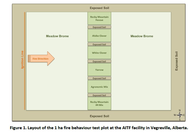
FPInnovations launched a multi-year study to determine whether a less-flammable, herbaceous species could replace the flammable grasses that typically colonize linear ROWs
Resource
Authors
Larry Turchenek
Wayne Tedder
R. Krzanowski
Methodology for cost-effective soil survey and sampling of cutover peatlands, and obtaining baseline chemical information and data interpretation for peat materials to examine reclamation alternatives
Resource
The objective of this project was to conduct a comprehensive market assessment of the native plant industry
Resource
Authors
Anne McIntosh
Bonnie Drozdowski
Dani Degenhardt
Chris Powter
Christina Small
John Begg
Dan Farr
Arnold Janz
Randi Lupardus
Delinda Ryerson
Jim Schiek
We developed a scientifically robust and financially sustainable monitoring protocol to enable a consistent assessment of ecological recovery at reclaimed industrial wellsites in forested lands
Resource
Authors
Megan Hornseth
Karine Pigeon
Doug MacNearney
Terrence Larsen
Gordon Stenhouse
Jerome Cranston
Laura Finnegan
Natural regeneration of seismic lines, cleared for hydrocarbon exploration, is slow and often hindered by vegetation damage, soil compaction, and motorized human activity. There is an extensive...
Resource
Authors
Ryan O’Neill
Jean-Marie Sobze
Catherine Brown
Improving seed emergence and survival is one of the largest potential benefits for native boreal seed enhancement. Seed pelleting can increase seed size by multiple orders of magnitude, resulting in...
Resource
Authors
Jay Woosaree
Brij Verma
Byron James
Phytoremediation, the use of plants to remove, degrade or stabilize sites contaminated with organic or toxic chemicals is gaining in popularity as an alternative and economical technique in...
Resource
Authors
Cassidy van Rensen
Scott Nielsena
Barry White
Tim Vinge
Victor Lieffers
Mapping of oil reserves involves the use of seismic lines (linear disturbances) to determine both their location and extent. Conventional clearing techniques for seismic assessment have left a legacy...
Resource
Authors
Richard Johnson
P. Bork
E.A.D. Allen
W.H. James
L. Koverny
The experiments detailed in this report show that it was possible to increase the solids content of sludge to 50% solids by adding three parts sand (tailings sand) to one part sludge.
Resource
Authors
Stephen Moran
Mark Trudell
Terry Macyk
Daphne Cheel
The first phase of the study, which was completed in 1984, included characterization and instrumentation of two study areas: the Battle River study area, which included Diplomat, Vesta and Paintearth...
Resource
Authors
Mark Trudell
Stephen Moran
Terry Macyk
This is one of a series of reports that presents the findings of the Plains Hydrology and Reclamation Project (PHRP), an interdisciplinary study that focuses primarily on hydrologic aspects of the...
Resource
Mapping of oil reserves involves the use of seismic lines (linear disturbances) to determine size of reserves. These linear disturbances fragment forests and in many cases fail to regenerate trees...
Resource
Authors
Bonnie Drozdowski
Craig Aumann
Chris Powter
Report of a seminar to develop a collective understanding of the benefits and opportunities of Predictive Soil Mapping as they relate to Alberta
Resource
Modelling results for the regional watersheds were encouraging and demonstrate that SWATBF has the potential to be utilized as a practical tool for conducting hydrologic assessments in the oil sands
Resource
Authors
Alberta Biodiversity Monitoring Institute
Boreal caribou populations are declining across Alberta and much of their Canadian range. Key factors causing this decline include a warming climate along with habitat change from industrial...
Resource
Authors
Alberta Biodiversity Monitoring Institute
Seismic lines and other linear features created by humans are thought to negatively impact woodland caribou. It is estimated that there are c. 100,000 km of conventional seismic lines in caribou...