Land Management Search Results
Resource
Resource Date:
December
2018
This practitioner guide provides a user-friendly overview of the interactions between boreal wetlands and forests and what these interactions mean for forest managers working in Canada’s boreal.
Resource
Resource Date:
December
2018
This technical report describes in detail the interactions between boreal wetlands and forests and how forest managers can use this information to help avoid or minimize adverse effects on wetlands.
Resource
Authors
Sini-Selina Salko
Jussi Juola
Iuliia Burdun
Harri Vasander
Miina Rautiainen
Boreal peatlands store ~25 % of global soil organic carbon and host many endangered species; however, they face degradation due to climate change and anthropogenic drainage. In boreal peatlands...
Resource
Authors
NAIT Centre for Boreal Research
This flowchart outlines each step of the treatment process for forest land (upland) vegetation as incorporated in the corresponding Decision Support Systems (DSS). View more tools by NAIT Centre for...
Resource
Authors
Tyler Rudolph
Doug MacNearney
Laura Finnegan
Resource Date:
October
2019
Abstract The gap between research and its implementation is an impediment to conservation of the environment. Translating science into actionable management and policy requires effective communication...
Resource
This guide provides information and guidance on how to plan and construct resource road wetland crossings in Canada's boreal plains.
Resource
Authors
Camille Defrenne
Jessica Moore
Colin Tucker
Louis Lamit
Evan Kane
Randall Kolka
Rodney Chimner
Jason Keller
Erik Lilleskov
Drainage-induced encroachment by trees may have major effects on the carbon balance of northern peatlands, and responses of microbial communities are likely to play a central mechanistic role. We...
Resource
Resource Date:
September
2023
Although peatlands cover only 3% of the world's land, they store about twice as much carbon as in the biomass of all the world's forests combined. Thus, they are incredibly important especially for...
Resource
Authors
Jacob Bradshaw
Chris Johnson
Carolyn Shores
Roy Rea
Resource Date:
March
2020
We investigated the effect of three forest-harvest prescriptions on the co-occurrence of caribou, sympatric ungulates, and predators: unharvested old-growth, clearcut harvesting, and group-selection..
Resource
Authors
Terry Macyk
Martin Fung
Ron Pauls
Syncrude Canada Ltd. produces 200,000 barrels of synthetic crude oil per day from its oil sands surface mining operations located 50 km north of Fort McMurray, Alberta. The three major types of...
Resource
Authors
A.U. Mallik
Y.L. Gong
F.W. Bell
Secondary succession, which follows forest harvesting, begins with the growth of herbs, shrubs, and trees and eventually leads to a mature forest. However, young, commercially important trees are...
Resource
Authors
Emily Ury
Puvaanah Arrumugam
Ellen Herbert
Pascal Badiou
Bryan Page
Nandita Basu
Resource Date:
April
2023
Wetland restoration is a popular nutrient management strategy for improving water quality in agricultural catchments. However, a wetland’s ability to retain phosphorus is highly variable and wetlands...
Resource
Authors
Alberta Biodiversity Monitoring Institute
This online report describes the status of human footprint, species, and habitat in Norbord Inc.'s two main operating areas located in northwestern Alberta. This information establishes baseline...
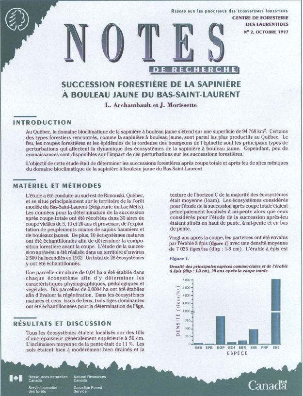
Resource
Authors
L. Archambault
J. Morissette
In Quebec, the bioclimatic zone of balsam fir-yellow birch covers an area of 94,768 km 2. Some of the forest cover types in the area, such as balsam fir-yellow birch, are among the most productive in...
Resource
Authors
Michael Ryan
David Fraser
Valin Marshall
Fangliang He
Six chronosequences were established on southern Vancouver Island, British Columbia, to address the concerns regarding the potential loss of species diversity and increased risk to rare or old-growth...
Resource
Authors
Angeline Van Dongen
Caren Jones
Amanda Schoonmaker
Jill Harvey
Dani Degenhardt
Resource Date:
November
2022
Alberta’s forests are becoming increasingly disturbed and fragmented by the cumulative effects of anthropogenic distur�bances exacerbated by the enduring footprint of seismic lines on the landscape...
Resource
Authors
Guillermo Castilla
Ronald Hall
Rob Skakun
Michelle Filiatrault
André Beaudoin
Michael Gartrell
Lisa Smith
Kathleen Groenewegen
Chris Hopkinson
Jurjen van der Sluijs
Resource Date:
February
2022
Wall-to-wall 30 m raster maps of broad forest type, stand height, crown closure, stand volume, total volume, aboveground biomass, and stand age were created for a ~400,000 km2 area, validated with independent data, and generalized into a polygon GIS layer resembling a traditional FI map. The MVI project showed that a reasonably accurate FI map for large, remote, predominantly non-inventoried boreal regions can be obtained at a low cost by combining limited field data with remote sensing data from multiple sources.
Resource
Authors
Karine Pigeon
Meghan Anderson
Doug MacNearney
Jerome Cranston
Gordon Stenhouse
Laura Finnegan
This resource is available on an external database and may require a paid subscription to access it. It is included on the CCLM to support our goal of capturing and sharing the breadth of all...
Resource
Authors
Katherine Dearborn
Jennifer Baltzer
Resource Date:
March
2021
This resource is available on an external database and may require a paid subscription to access it. It is included on the CCLM to support our goal of capturing and sharing the breadth of all...
Resource
Dr. David Andison is program lead of the fRI Healthy Landscapes program. He begins by explaining the "Why" of ecosystem management and how current approaches to land management fragments the landscape...