Land Management Search Results
Resource
This report identifies historical, annual and open water, low flow sequences for 13 stations in the Athabasca River Basin which can be used to determine management guidelines for the River basin
Resource
Monthly flows are provided for the period 1912 to 1980 at 21 locations on the Athabasca River and its major tributaries. The flow data sets are suitable for water management planning
Resource
Nearly 76% of all water used in the basin in 1981 was obtained from the river, 22% from major tributaries and other surface sources, and the remaining 2% from groundwater
Resource
Authors
H. Yau
K.L. Murphy
P.L. Timpany
Once the composite model is calibrated and tested, it would predict mass loading or concentration of a parameter at any point along the study area for different future development scenarios
Resource
Pesticide Chemicals Branch of Alberta Environment conducted a monitoring program in 1979 related to two methoxychlor treatments of the Athabasca River for black fly (Simulium arcticum) control.
Resource
The use of methoxychlor in the Athabasca River to control black fly (Diptera: Simuliidae) larvae was monitored in 1980. Effective control of black fly was observed for a distance of 60 km
Resource
Population reductions of non-target organisms in the Athabasca River due to methoxychlor was limited for the May 20/21 treatment but was considerable for the June 19 treatment.
Resource
Authors
Gordon Macdonald
Alfred Rademacher
Changes in effluent loadings at the two pulp mills and an increase in river flows in the lower Athabasca Basin accounted for some noticeable improvements in water quality from that reported in 1990
Resource
Significant factors relating to effects on physical and chemical characteristics of the northern Alberta environment as a result of potential oil sands development in the Athabasca tar sands were docu
Resource
13 recommendations related to tailings, reclamation, data access, regional plan, economics, research coordination, groundwater and the Athabasca River
Resource
Ruth Lake is a small, littoral, moderately eutrophic lake. Poplar Creek is a small, brownwater tributary of the Athabasca River.
Resource
Authors
M.S. Thompson
J. Crosby-Diewold
Relationship between aquatic macrophyte growth and habitat factors found in the AOSERP study area is outlined, as are some implications of aquatic macrophyte inventory for management and revegetation
Resource
Investigations were carried out on the Athabasca River upstream of Fort McMurray to determine the baseline quantities of organic constituents and their contribution to the organic water quality
Resource
Authors
Peter McCart
Philip Tsui
William Grant
Roderick Green
The study consisted of three parts: 1) A general reconnaissance early in the study period including a survey of fish species, benthic invertebrates, periphyton (attached algae) and water quality
Resource
Authors
Peter McCart
Philip Tsui
William Grant
Roderick Green
Derek Tripp
Peak discharge for the year was 22.5 m3/sec and the low 0.2 m3/sec. A total of 80 benthic macroinvertebrate taxa and 19 fish species were collected.
Resource
Authors
Aneta Spyra
Anna Cieplok
Mariola Krodkiewska
Beaver-created ponds constitute an important element of small water retention in forest catchments and preserving biodiversity as breeding sites for vertebrates and invertebrates. In many areas, these...
Resource
Authors
Nicole Balliston
Jonathan Price
Resource Date:
April
2022
This resource is available on an external database and may require a paid subscription to access it. It is included on the CCLM to support our goal of capturing and sharing the breadth of all...
Resource
Boreal peatlands store approximately one third of the earth’s terrestrial carbon, locked away in currently waterlogged and frozen conditions. Peatlands of boreal and arctic ecosystems are affected...
Resource
Authors
Alberta Biodiversity Monitoring Institute
We’re pleased to announce the release of the ABMI Alberta-wide Wetland Inventory—our most up-to-date and high-resolution wetland data yet.
Resource
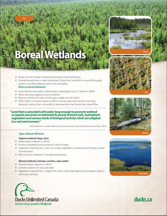
These fact sheets highlight plant, soil, and water indicators and key ecological benefits of each of the five major wetlands types.