Land Management Search Results
Project
This project is a part of the Government of Canada’s initiative for monitoring and assessing regional cumulative effects, a recently added requirement to the new Impact Assessment Act (2019). Among...
Resource
Authors
Emily Ury
Puvaanah Arrumugam
Ellen Herbert
Pascal Badiou
Bryan Page
Nandita Basu
Resource Date:
April
2023
Wetland restoration is a popular nutrient management strategy for improving water quality in agricultural catchments. However, a wetland’s ability to retain phosphorus is highly variable and wetlands...
Resource
Authors
Alberta Biodiversity Monitoring Institute
This online report describes the status of human footprint, species, and habitat in Norbord Inc.'s two main operating areas located in northwestern Alberta. This information establishes baseline...
Resource
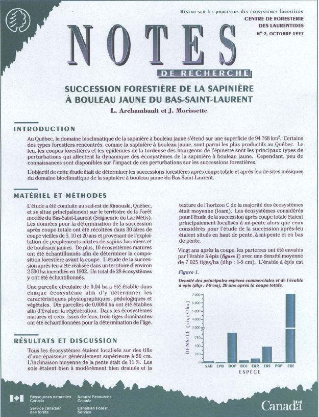
Authors
L. Archambault
J. Morissette
In Quebec, the bioclimatic zone of balsam fir-yellow birch covers an area of 94,768 km 2. Some of the forest cover types in the area, such as balsam fir-yellow birch, are among the most productive in...
Resource
Authors
Michael Ryan
David Fraser
Valin Marshall
Fangliang He
Six chronosequences were established on southern Vancouver Island, British Columbia, to address the concerns regarding the potential loss of species diversity and increased risk to rare or old-growth...
Resource
Authors
Angeline Van Dongen
Caren Jones
Amanda Schoonmaker
Jill Harvey
Dani Degenhardt
Resource Date:
November
2022
Alberta’s forests are becoming increasingly disturbed and fragmented by the cumulative effects of anthropogenic distur�bances exacerbated by the enduring footprint of seismic lines on the landscape...
Resource
Authors
Guillermo Castilla
Ronald Hall
Rob Skakun
Michelle Filiatrault
André Beaudoin
Michael Gartrell
Lisa Smith
Kathleen Groenewegen
Chris Hopkinson
Jurjen van der Sluijs
Resource Date:
February
2022
Wall-to-wall 30 m raster maps of broad forest type, stand height, crown closure, stand volume, total volume, aboveground biomass, and stand age were created for a ~400,000 km2 area, validated with independent data, and generalized into a polygon GIS layer resembling a traditional FI map. The MVI project showed that a reasonably accurate FI map for large, remote, predominantly non-inventoried boreal regions can be obtained at a low cost by combining limited field data with remote sensing data from multiple sources.
Resource
Authors
Karine Pigeon
Meghan Anderson
Doug MacNearney
Jerome Cranston
Gordon Stenhouse
Laura Finnegan
This resource is available on an external database and may require a paid subscription to access it. It is included on the CCLM to support our goal of capturing and sharing the breadth of all...
Resource
Authors
Katherine Dearborn
Jennifer Baltzer
Resource Date:
March
2021
This resource is available on an external database and may require a paid subscription to access it. It is included on the CCLM to support our goal of capturing and sharing the breadth of all...
Resource
Dr. David Andison is program lead of the fRI Healthy Landscapes program. He begins by explaining the "Why" of ecosystem management and how current approaches to land management fragments the landscape...
Resource
Boreal forests are regularly subjected to natural disturbances, which affect forest structure, composition, age distribution, biodiversity, and ecosystem function. Forest biodiversity shows continual...
Resource
This webinar introduces the guiding principles, objectives, and planning considerations for wetland stewardship, and discusses how these concepts can be applied in the context of forest management.
Resource
Our Nature talk on Tuesday, July 4th, featured Rachel Kendall and her work surrounding the forested wetlands of Nova Scotia. Rachel loves exploring and gaining new understandings of how plants, soil...
Resource
Resource Date:
January
2018
This presentation provides an overview of a long-term university-industry research partnership to improve understanding of peatland ecosystem function and reclamation techniques.
Resource
Resource Date:
January
2019
This presentation highlights the value of wetlands to forest management and the role wetlands play in sustaining healthy forested ecosystems.
Resource
Moderate to rich fens covered with tamarack and black spruce cover large areas of Alberta. These peatlands are nearly pH neutral and are characterized by hummock-hollow topography where the hummocks...
Project
In January 2016, Ducks Unlimited Canada (DUC) hosted a two-day Wetlands Best Management Practices (BMP) Workshop. The workshop focused on collaborative engagement with participants to discuss planning...
Resource
Authors
The Forest Management and Wetland Stewardship Initiative
This practitioner guide is a user-friendly compilation of wetland best management practices that can be applied to incorporate wetland stewardship into forestry planning and operations.
Resource
Authors
Bev Gingras
Jules Lebeouf
Kylie McLeod
Leanne Mingo
These proceedings describe the findings of the Wetland Best Management Practices (BMPs) Workshop held on January 20th & 21st 2016 in Edmonton, Alberta hosted by Ducks Unlimited Canada.
Resource
Authors
Wetland Knowledge Exchange
Resource Date:
February
2021
The Wetland Knowledge Exchange releases monthly newsletters that highlight new research, publications, news, interesting facts, events and more. In this edition you will learn about: State of Canada's...