Land Management Search Results
Resource
Authors
David Latham
Cecilia Latham
Mark Boyce
Stan Boutin
In this study, we examined seasonal coyote and black bear use of industrial linear features and rivers and streams (i.e. natural linear features). We used two methods to assess movement behavior...
Resource
Authors
Chibuike Chigbo
Amanda Schoonmaker
Dani Degenhardt
Land application of biosolids may be an effective strategy to improve soil quality and better support the establishment of native vegetative cover on an industrial footprint with marginal soil...
Resource
Authors
L.M. Hachey
Audrey Lanoue
The focus of this paper is the development of a physically sound three-dimensional model of the final closure landscape for the 2011 Life of Mine Closure submission
Resource
Authors
Jennifer Hird
Alessandro Montaghi
Gregory McDermid
Jahan Kariyeva
Brian Moorman
Scott Nielsen
Anne McIntosh
Good statistical agreement between key structural vegetation parameters, such as mean and maximum vegetation height, with PPC metrics successfully predicting most height and tree-diameter metrics.
Resource
Authors
William Wadsworth
Ave Dersch
Robin Woywitka
Kisha Supernant
The Athabasca Oil Sands (AOS) region of Alberta has one of the densest accumulations of known archaeological sites, and possibly the most archaeological sites at risk, in the country. Expanding...
Resource
Authors
Spencer Chad
Lee Barbour
Jeffrey McDonnell
John Gibson
Water samples were collected and analyzed regularly over an eight-year period to establish inventories of site-wide water isotope signatures including seasonal and interannual changes in the recycle...
Resource
Authors
Emma Bocking
David Cooper
Johnathan Price
Resource Date:
November
2017
This resource is available on an external database and may require a paid subscription to access it. It is included on the CCLM to support our goal of capturing and sharing the breadth of all...
Resource
Authors
Laureen Echiverri
Ellen Macdonald
Resource Date:
September
2019
For the purpose of informing biodiversity conservation efforts in managed landscapes, we explored whether and how understory plant communities (abundance, diversity, composition) were related to a...
Resource
Authors
Tegan Holmes
Tricia Stadnyk
Masoud Asadzadeh
John Gibson
This study evaluates whether combined use of streamflow and isotope tracer performance metrics can improve representation of simulated streamflow-generating processes within a large river basin, the...
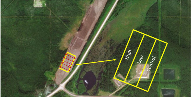
Resource
Authors
Dave Reid
Jim Sherstabetoff
Eleven major vegetation types were identified and are mapped at a scale of 1:20 000 on the eastern portion of Syncrude Lease 17.
Resource
Seismic lines are slow to recover naturally, and many seismic lines need to be restored to contribute towards caribou recovery. Caribou predators use seismic lines to travel throughout caribou ranges...
Resource
This guidebook explains vegetation management tools and techniques. Natural Resources Canada Canadian Forest Service (NRCan-CFS) developed this guidebook to help with the successional restoration of...
Resource
Authors
Everett Peterson
Allan Levinsohn
Black Spruce - Labrador Tea was the dominant vegetation type, making up 35.0% of the 9,250 ha study area. The 2nd most abundant type was Aspen - White Spruce (26.0%) and the 3rd was White Spruce – Asp
Resource
Field data on the abundance (or percent cover) of vascular plants, bryophytes, and soil mesofauna were obtained in the summer of 2008 and 2009 from nine produced water release sites in Alberta and...
Resource
Resource Date:
November
2020
The Vermillion River watershed region, found in central Alberta between Edmonton and Lloydminster, is home to residents and farmers who rely on the watershed for drinking water, agriculture, and...
Resource
Authors
Jack Mercer
Robert Charlton
Imagery from both meteorological and environmental satellite sensor systems was analyzed to determine its applicability in monitoring weather conditions at the Alberta oil sands.
Resource
Resource Date:
January
2016
With over 75 years of experience and activity in every province and territory, Ducks Unlimited Canada (DUC) is a registered charity and a recognized leader in wetland conservation. DUC is a science...
Resource
Authors
Marc Mayhew
Amanda Schoonmaker
Allan Pollock
This presentation discusses a comparison of site preparation methods on sub-surface soil resistance and moisture on reclaimed industrial sites in northwestern Alberta.
Resource
Dr. Richard McCleary draws the links between what we see in the field to the maps we have for planning and points out that the information we need for watershed assessment and riparian zones is the same.
Resource
This presentation describes a method of assessing cumulative effects, taking into account the many drivers or pressures on the landscape and their effects on watershed processes.