Land Management Search Results
Resource
One-hundred-year-old mixed white spruce–aspen stands were partially cut in 1953, 1954, and 1955 and scarified leaving treatments that retained 14–100% of total stand basal area. Composition of the...
Resource
Authors
Alberta Biodiversity Monitoring Institute
This online report describes the status of human footprint, species, and habitat in Norbord Inc.'s two main operating areas located in northwestern Alberta. This information establishes baseline...
Resource
This study examined three pervasive issues that impacted native ecosystems. Numerous land use practices including oil and gas activities have led to the modification of native grasslands both the...
Resource
Authors
L. Archambault
J. Morissette
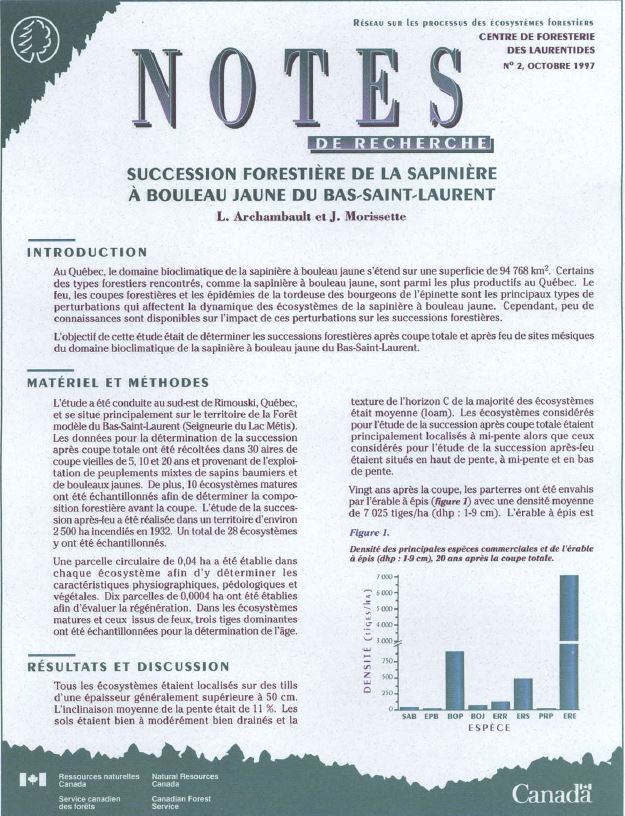
In Quebec, the bioclimatic zone of balsam fir-yellow birch covers an area of 94,768 km 2. Some of the forest cover types in the area, such as balsam fir-yellow birch, are among the most productive in...
Resource
Authors
Michael Ryan
David Fraser
Valin Marshall
Fangliang He
Six chronosequences were established on southern Vancouver Island, British Columbia, to address the concerns regarding the potential loss of species diversity and increased risk to rare or old-growth...
Resource
Authors
Matthew Pyper
Chris Powter
Tim Vinge
For reclaimed lands to be considered self-sustaining they should respond to natural and anthropogenic disturbances in a similar manner to how an analogous undisturbed landscape might respond
Resource
Authors
Oil Sands Research and Information Network
Canadian Environmental Assessment Agency
Develop common understanding of the current knowledge regarding groundwater resources, groundwater-surface water interactions in the oil sands area, ongoing applied research, monitoring and impacts
Resource
Authors
Oil Sands Research and Information Network
Survey demonstrated need to better communicate availability of existing information and continue to make efforts to provide easy, timely and transparent access to monitoring and research information
Resource
Differences in microtopography were associated with differences in plant species richness and composition between OSE pads and the undisturbed sites.
Resource
Authors
Craig DeMars
Kendal Benesh
The boreal ecotype of woodland caribou ( Rangifer tarandus caribou) is provincially Red-listed in British Columbia and federally listed as Threatened. Population declines of boreal caribou have been...
Resource
Authors
Paul King
G. Granger
A. Straka
The results of preliminary experiments on pre-germination treatment methods for nine selected native woody plant species for disturbed land reclamation in the Rocky Mountain Eastern Slopes of Alberta.
Resource
UAV-based remote sensing as a method for monitoring well pad recovery is determined to be feasible from a technical and field perspective.
Resource
Authors
Janice Paskey
Gillian Steward
A clear majority of journalists said that there are many stories about the oil sands that go unreported and many of these unreported stories have to do with environmental issues
Resource
Authors
Janice Paskey
Gillian Steward
A. Williams
In the last 10 to 15 years, global issues such as climate change, indigenous rights, pollution of the air and major waterways, and sustainability have become embedded in the oil sands discourse
Resource
The Development and Reclamation Review process, as it currently operates, is presented and discussed with the aid of a flow chart. Suggestions are made to improve and expedite the process with...
Resource
Resource Date:
August
2020
This document is part of the 360 tours project Toolkit developed by Canada's Oil Sands Innovation Alliance (COSIA) led by Cenovus Energy Inc., in collaboration with Natural Resources Canada. The...
Resource
Authors
Erin Bayne
Cameron Nordell
Jesse Watson
Melynda Johnson
Adam Moltzahn
Janet Ng
The Ferruginous Hawk (FEHA) has been listed as an Endangered Species under the Alberta Wildlife Act by the provincial government since 2006 (Alberta FEHA Recovery Team 2009); and were re-listed as a...
Resource
Authors
Angeline Van Dongen
Caren Jones
Amanda Schoonmaker
Jill Harvey
Dani Degenhardt
Resource Date:
November
2022
Alberta’s forests are becoming increasingly disturbed and fragmented by the cumulative effects of anthropogenic distur�bances exacerbated by the enduring footprint of seismic lines on the landscape...
Resource
Study concentrated on the well-documented 1981 right-of-way, and compared it to the oldest trench, installed in 1957, and to the undisturbed adjacent mixed prairie
Resource
Authors
Guillermo Castilla
Ronald Hall
Rob Skakun
Michelle Filiatrault
André Beaudoin
Michael Gartrell
Lisa Smith
Kathleen Groenewegen
Chris Hopkinson
Jurjen van der Sluijs
Resource Date:
February
2022
Wall-to-wall 30 m raster maps of broad forest type, stand height, crown closure, stand volume, total volume, aboveground biomass, and stand age were created for a ~400,000 km2 area, validated with independent data, and generalized into a polygon GIS layer resembling a traditional FI map. The MVI project showed that a reasonably accurate FI map for large, remote, predominantly non-inventoried boreal regions can be obtained at a low cost by combining limited field data with remote sensing data from multiple sources.