Boreal Caribou Search Results
Resource
Authors
Jean Birks
Yi Yi
Sunny Cho
John Gibson
Rod Hazewinkel
Goal was identifying whether atmospherically-derived organics present in snow are a significant contributor to the organics detected in rivers and lakes in the oil sands region
Resource
Authors
D.W. Mayhood
Linda Corkum
Baseline data available on the Muskeg River hydrology, benthic invertebrates, plankton and fish are generally useful, but additional information is desireable
Resource
The present volume evaluates the 1980 monitoring program, and makes suggestions for the conduct of future monitoring studies on the Muskeg River and elsewhere in the AOSERP area
Resource
Authors
Chris Powter
Brent Scorfield
Brent Lakeman
Shane Patterson
The development of integrated geomatics and remote sensing technologies for environmental management holds promise to meet economic diversification and effective environmental management.
Resource
Authors
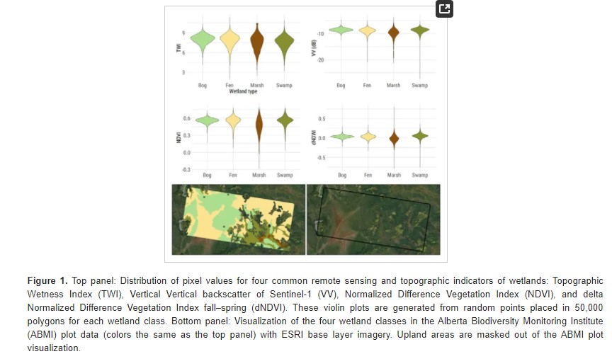
Evan DeLancey
John Simms
Masoud Mahdianpari
Brian Brisco
Craig Mahoney
Jahan Kariyeva
Developed two wetland inventory style products for a large (397,958 km2) area in the Boreal Forest region of Alberta, Canada, using Sentinel-1, Sentinel-2, and ALOS DEM data
Resource
Authors
Bev Gingras
Cynthia Paszkowski
Garry Scrimgeour
Sharon Kendall
Objective was to compare the effectiveness of four commonly used sampling techniques (pitfall traps, funnel traps, visual searches and call surveys) to detect stream amphibian communities.
Resource
Authors
Lauren Thompson
McKenzie Kuhn
Johanna Winder
Lucas Braga
Ryan Hutchins
Andrew Tanentzap
Vincent St. Louis
David Olefeldt
Resource Date:
January
2023
Permafrost thaw may increase the production of neurotoxic methylmercury (MeHg) in northern peatlands, but the downstream delivery of MeHg is uncertain. We quantified total mercury (THg) and MeHg...
Resource
Authors
Greg McDermid
Julie Lovitt
Mustafizur Rahman
Maria Strack
Saru Saraswati
Bin Xu
This presentation discusses remote sensing to assess groundwater, microtopogpraphy and above-ground biomass, as well as wetland management. Presented at the NAIT 7th Seminar on Linear Disturbance...
Resource
Authors
James Saracco
Peter Pyle
Danielle Kaschube
Monica Kohler
Christine Godwin
Kenneth Foster
Habitat loss and disturbance from industrial resource development may be contributing to declines in boreal bird populations. We applied hierarchical multi-species models to data from 31 bird species...
Resource
Authors
Troy Sorensen
Philip McLoughlin
Dave Hervieux
Elston Dzus
Jack Nolan
Bob Wynes
Stan Boutin
This resource is available on an external database and may require a paid subscription to access it. It is included on the CCLM to support our goal of capturing and sharing the breadth of all...
Resource
Authors
Alberta Biodiversity Monitoring Institute
This report is part of a larger endeavor to develop a monitoring program capable of detecting changes in the biological diversity of Alberta’s forested region.
Resource
Long-term monitoring of some sites would ultimately be needed to show that recovering wellsites are on a trajectory that consistently leads to full recovery.
Resource
Authors
Sarah Thacker
Sara Venskaitis
Kevin Renkema
Emily Herdman
Earth observation (EO), remote sensing (RS), and other digital technologies are emerging as powerful tools for monitoring the environment and collecting environmental data. These technologies can be...
Resource
Resource Date:
January
2016
This presentation provides an overview of the Ducks Unlimited Canada Enhanced Wetland Classification System, including current and potential uses for wetland conservation and management.
Resource
Pilot study to assess the use of early successional stands (i.e. those ranging in age from 4 to 17 years) by wildlife (songbirds, small mammals, and ungulates), using a wildlife monitoring protocol
Resource
Authors
Roger DeAbreu
Shane Patterson
Todd Shipman
Chris Powter
NRCan pilot science projects have proven that Earth Observation can provide relevant and valuable information to inform and enhance monitoring and support regulatory frameworks
Resource
There was only very limited evidence of biological responses to increased pollutant content in spite of significantly higher pollutant levels in tissues close to existing industrial developments.
Resource
Authors
M.D. Thompson
M.C. Wride
M.E. Kirby
Classification system devised for mapping vegetation and surficial geology from 1:60,000 scale false colour infrared photographs; 1:50 000 base maps plus a vegetation and a surficial geology overlay
Resource
Ground surveys of vegetation and surficial geology generally confirmed that the classification systems used in the mapping accurately described and defined the ecological habitat features
Resource
Authors
ERMP Project Advisory Group
Monitoring protocols for forested land wellsites to determine if a reclaimed site has returned to similar structure and function as found in a representative undisturbed reference area.